Tuesday, September 30, 2008

Lidar on Mars: The Movie

Kurt sent me a great movie clip showing an animation of the Optech lidar system on the Phoenix Mars Polar Lander and a series of false-color composite still frames.

You can really see the laser as it reflects off particles in the atmosphere. Note the rather large flash that shows up to the left of the laser. I am not sure what is going on there. Perhaps an accumulation of dust particles?

(if this plays really fast the first time, try playing it again. For some reason, the second time plays slow enough that you can see the flash)

Friday, September 26, 2008

Mac Tablets

Though not distributed by Apple, it appears that Mac tablets are here:


Axiotron Modbook

I have to admit, they do seem pretty sweet. I think I am too tied to manually typing to be able to work sans keyboard though (this guy is a slate, not a convertible), and the price is pretty steep (entry price $2,290). I currently have an Acer Tablet PC (the Travelmate C300, which is a convertible) that is about 4 years old. I cannot remember how much it cost when I first got it, but I know it was nowhere near this much. Of course, the Modbook is a lot more powerful (2.1 gHz processor, available w/ 2.4) and it even comes with a built-in GPS!

How long can I survive?

Apparently not very long....

I could survive for 47 seconds chained to a bunk bed with a velociraptor

Sunday, September 21, 2008

The Fighting Cartographers!

In a segment called "Smokin' Pole - American Arctic Expert" Stephen Colbert gives his spin on the Arctic mapping effort:

The Great Arctic Conflict - Media spin of Law of the Sea

In Betsy Baker's lastest blog post, #19 Conflict in the Arctic? The Tenacity of Media Spinshe highlights an important issue in current Law of the Sea operations: the media spin. I guess the idea that the US can peacefully map in the Arctic alongside Canadaian vessels and without causing a Russian military response is just too humdrum for the media. They need hype, they need drama, they need the threat of an international incident. 

Earlier in the year I was dismayed by an arcticle in Discover Magazine (January 2008 issue, page 22) that played up last year's Law of the Sea mapping expedition as a hurried response to the Russian's dropping their flag at the North Pole. They actually implied that the Healy was diverted off her current course to run up to the Arctic in a show of American force:

"Within days of the twin Mir descent, the U.S. Coast Guard had dispatched the icebreaker Healy north of Alaska to spend nearly a month mapping the Arctic Ocean's floor..."

Nevermind the fact that a quick Google search would have taken them to CCOM's Law of the Sea  webpage where not only can you see that we have been mapping up there since 2003, but also that the data is publicly available for download. Yes, even the Ruskies can download it (gasp!). I should also point out that in June of 1990, the US and Russia signed the U.S.-USSR Maritime Boundary Agreement, which will still hold even during EEZ extensions under Law of the Sea.

Sadly, Discover was only one in any number of magazines and newspapers to twist this story. This year, it seems, will be no different. The New York Times is another culprit, as evidenced by a recent article, "Arctic in Retreat" (September 8, 2008), the subject of Betsy's blog. The "disputes" and "conflicts" mentioned in these articles are simply nonexistent. Sure, countries are mapping the Arctic so they can submit their claims to the Law of the Sea Commission, but that is about as heated as gets right now. 

I am sure this is just the start. It will be interesting to see how the media continues to spin international mapping expeditions in the Arctic, especially as the ice continues to retreat and the Arctic itself becomes more accessible. 

Friday, September 19, 2008

Healy makes Ship of the Week!

Thanks to Kurt for pointing this out to me:


"In keeping with the arctic theme, this weeks Interesting Ship is the United States Coast Guard Cutter Healy  (WAGB-20).  The ship is a research icebreaker that was first put into commission on November 10, 1999.  Healy  provides more than 4,200 square feet of laboratory space, numerous electronic sensor systems, oceanographic  winches, and accommodations for up to 50 scientists.  It is capable of breaking 4 1/2 feet of ice continuously at  three knots and can operate in temperatures as low as -50 degrees F."

Wednesday, September 17, 2008

USCGC Healy and the CCGS Louis St-Laurent

After we disembarked the Healy on Sept. 5  and helo ops were completed the next day, Healy met up with the Canadian Coast Guard icebreaker the Louis St. Laurent. During this mission, Healy will be breaking ice for the Louis St-Laurent allowing her to tow seismic gear in order to map the sub-bottom. Healy will be collecting multibeam data during the course of the operations. 

According to the USCG's Healy update webpage,  the Louis St-Laurent has been helping out Healy as well, breaking ice for her as they transit to the seismic sites in order to improve the multibeam data quality. 


Back on Sept. 3, as we were headed back to Barrow,  the Louis St-Laurent sent her helicopter over to say hello:


On Sept. 5 the Healy commenced her own helo ops, bringing new people aboard, taking old people off, and of course, delivering the mail (no mail buoys for this Coast Guard vessel!):


USCGC Healy Blogs and Twitter

The USCGC Healy, the ice breaker I just spent 3 and a half weeks on in the Arctic, is now twittering! 

Follow along here: http://twitter.com/cgchealy

You can also read about our Healy cruise and other Law of Sea news in the blog of Betsy Baker, a lawyer and professor who specializes in Law of the Sea was onboard with us.

Read Betsy Baker's blog here: http://arctic-healy-baker-2008.blogspot.com/

Betsy did what I should have done, send the blog updates and photos to someone with web access and have them update it for you.

For more polar science goodies check out the Exploratorium's weblog entitled "Ice Stories: Dispatches from Polar Scientists", which also includes tales from the Healy.


As for me, over the next couple days I intend to get some of pictures posted on here from the trip. It was an amazing 3 weeks and I am hopeful that I will have the chance to go back one day.


Sunday, September 14, 2008

The Foot


If you got my Healy emails, then you probably saw an example of what the foot of the continental slope looks like in the sub-bottom profiler image. I thought I would post the image here as well, because I just think it is so cool. I am still amazed sometimes at how far technology has come. I mean think about it. We are using sound to map what is beneath the seafloor. How cool is that??

   
Below is an image of the foot of the slope captured as we first passed over it on August 18 (click on it to get the full size image). You can see the layers of sediment pile up on the slope as it drops off. This is a raw image, so the numbers running vertically along the image are time in seconds, not depth. In a nutshell, depth is measured by recording the two-way travel time of the sound wave and multiplying it by the speed of sound through the water and sediment. This image also has a roughly 20x vertical exaggeration, so the slope looks a lot steeper than it really is. 


Wednesday, September 10, 2008

Back to Reality

As the jet lag wears off and I readjust to normal day/night cycles, I am slowly coming back to reality.

My days on the ship were spent watching data being collected at a rate that is slightly less than the rate of grass growing, processing said data, snapping more pictures of ice than one would think possible, and keeping my fingers crossed for polar bear sightings.

Now my days are spent in a cubicle with no ice (though that will surely change in a couple months) and no chance of polar bears. Today I spent a portion of my day Googling where to buy sediment.

*sigh*....

Thursday, September 4, 2008

Update from the Arctic!

Hello again from the Arctic! Now that we are headed back to Barrow and are subsequently south of 80 degrees, we have web access again (albeit, intermittently). A lot of you have been getting semi-regular updates via email of my adventures while at sea, but I thought I would summarize some of the highlights for the blog:


Tuesday, Aug 19:

I saw my first set of polar bear tracks today! Actually, I saw two. At least one of them was fairly fresh because you could still see detail (e.g. the individual pad marks) in each print. I think I heard a ring seal today as well. I did not see it, but I heard it bark. There are also bearded seals up here, but apparently they are of the non-barking seal variety.

I also saw an icebow, which is essentially a rainbow that forms over ice. The colors are very faint and for the most part the icebow is all white. Now some folks out here have said the icebows are really fogbows, since although they start and end over the ice, the main body is in the fog. Fogbows can form wherever there is fog though, and are not constrained to the ice. Whatever it is, they are pretty cool!


Thursday, Aug 21:

Today was simply amazing. Just after I got off shift we entered an area of pressure ridging, where two ice flows are pushed together. For you geo buffs, this is analogous to convergent margins. Sometimes both edges of the ice ride up and form ridges of ice and snow. Polar bears like to use these to perch on and look out over the land (probably for their next meal). Depending on the thickness and age of the two ice flows, one can override the other, just like in subduction zones. Pretty cool, eh?

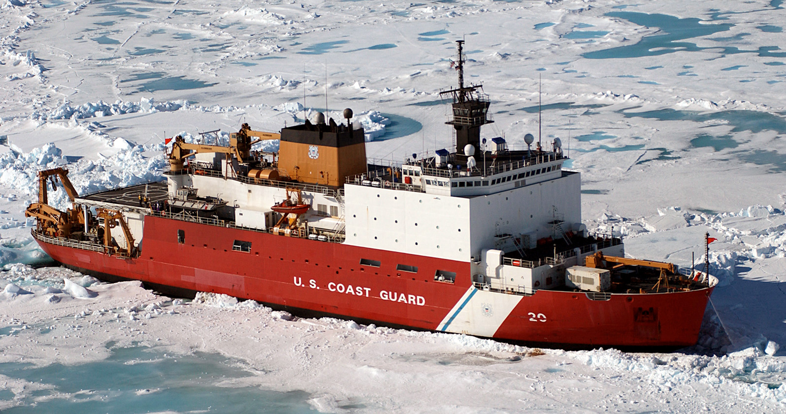
The pressure ridges today were pretty vast and were surrounded by pools of aquamarine. As the ice gets old, it becomes compacted and less saline, turning more and more blue as it does so. We got stuck several times and had to back up and ram repeatedly. We finally broke through when they brought on a second engine. The Healy has four engines, 3 that can be used together if necessary and one that is always kept for emergencies only. Standing on the bow as Healy broke through the ice was an amazing experience. You could really hear the ice break and watch the crack propagate out in front of us. As ice is pushed down underneath the ship, the sound of it scrapping along the hull is tremendous. Luckily, the multibeam sonar and sub-bottom profiler are protected by ice windows!

Right now we are still in "drive-by-cursor" mode. Essentially we are just following the foot of the continental slope to see where it goes. Most continental margins are comprised of a continental shelf, slope, and rise. The foot of the slope is defined as the maximum change in slope where the slope and the rise meet. Up here in the Arctic the continental margin has no rise, and oceanic sediments pile directly up onto the slope. We can see this clearly using the sub-bottom profiler, which produces a low frequency sound wave that sweeps between 3.6 and 6 kHz. The low freq. sound is able to penetrate the seafloor and reflect off layers of sediment and underlying rock, giving us an image.

Still no polar sightings. Well, not by me anyway… The bridge has spotted a couple, and did a couple of the night watchstanders. I am keeping my fingers crossed.


Thurday, Aug. 28:

Last night I managed to stay up and watch the sunset. Actually, it is more of a sun-"lowering" I suppose and really all it does is make a slight arc in the sky. We are at ~ 83 degrees North, so it never gets dark at all now. At the most, we get some shades of pink.

Dredging operations are slated to start on Friday and we hope to have our first ice buoy deployment sometime in the next couple of days. This will involve actually putting people on the ice (not me, unfortunately). There will be two watchstanders armed with rifles, one with the guys on the ice, and one on the boat, to look out for polar bears.

Still have not seen a polar bear. L Word has it that a number of bears have been seen just off the north Alaskan coast, so we are hopefully to spot more bears on our return to Barrow.


Wednesday, Sept. 3:

I SAW A POLAR BEAR!

At approximately 10 pm local time, a bear was spotted off our fantail. When I first ran outside I could not see him and I was crushed. The boat slowly started coming around to starboard and inching up to the ice. The encounter was amazing! We must have spent 15 or 20 minutes or so just watching as the bear walked around, sniffing the air and searching for food. At one point he stuck his nose in a hole in the ice and starting digging around. Eventually he crossed in front of our bow and walked off into the distance.


Here are some pics from my adventures. Once I have a better internet connection, I will post some more.


me on the bow of the Healy:


The sun and the bear (he's small, but he's there):


A picture of the bear taken with a camera much better than mine: