Fugro, one of the world's leading survey companies both on- and offshore, looks like they are about to acquire the Australian-based Tenix LADS Cooporation. Tenix LADS is one of the global providers of airborbe lidar bathymetry, and has completed many contracts under NOAA and the US Navy. Another one of Fugro's subsidies, Fugro Pelagos Inc., also conducts surveys for NOAA utilizing an Optech SHOALS-1000T lidar system.
Here is the full blurb at Hydro International: http://www.hydro-international.com/news/id3216-Fugro_Acquires_Tenix_LADS.html

Showing posts with label Tenix LADS. Show all posts
Showing posts with label Tenix LADS. Show all posts
Monday, June 8, 2009


Monday, May 25, 2009
Seamless land/sea mapping with Lidar
I am currently working up some Tenix LADS MKII lidar data over the Isles of Shoals off the coast of New Hampshire. I must say, the data set is quite impressive. Not only does the lidar bathymetry match very well with EM3002 multibeam bathymetry we have in the same area (initial comparison shows a mean difference of 0.6 m w/ a std: 0.3 m), but the seamless transition of the lidar data from water to land follows very closely the transition between the foreshore and the water (soundings are reduced to MLLW).
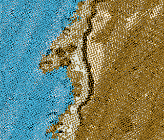
Here you can see the transition from depth soundings (blue) to terrain heights (brown) from the LADS lidar system. The flightlines are oriented north-northeast by south-southwest. NOAA chart 13283 is peeking out from behind the soundings. You can just see how the transition in sounding type roughly follows the foreshore line (MLLW) on the chart.
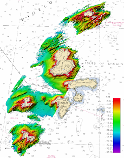
What does the bathymetry from the LADS MKII lidar look like? Here's a peak of some of the lidar bathy data (blue soundings only) gridded at a 4-meter resolution and displayed in Fledermaus. Sun illumination is from the northwest and the vertical exaggeration is 3. NOAA chart 13283 is in the background.
Here you can see the transition from depth soundings (blue) to terrain heights (brown) from the LADS lidar system. The flightlines are oriented north-northeast by south-southwest. NOAA chart 13283 is peeking out from behind the soundings. You can just see how the transition in sounding type roughly follows the foreshore line (MLLW) on the chart.

What does the bathymetry from the LADS MKII lidar look like? Here's a peak of some of the lidar bathy data (blue soundings only) gridded at a 4-meter resolution and displayed in Fledermaus. Sun illumination is from the northwest and the vertical exaggeration is 3. NOAA chart 13283 is in the background.

Subscribe to:
Posts (Atom)